

Time Present and Time Past
are both perhaps present in time future

Canada’s big (I think I’ve said that before, haven’t I?) The round trip to Halifax and back was planned to come in at 13,078 km, but it will be a bit more as we’ve already done some side trips and dodged off the highway onto side roads, and time allowing, might do some more.1
Ah, yes, Time.
Travelling such a distance means that as well as covering ten provinces, we cross five of the country’s six time zones:
1) Pacific
2) Mountain
3) Central
4) Eastern
5) Atlantic
These five cover a difference of four hours. Were we to be making the journey to Newfoundland and Labrador, we’d be contending with the weirdism of the country’s sixth time zone – which is *half an hour* different from its neighbour.
So, how does it work out in practice?
A deep breath, and a prayer for forgiveness for the things I’m almost certainly going to get wrong given the insane complexity of the issue, and the fact that it took me two attempts to pass the O Level maths over forty years ago.
The first thing to say is that the apparent position of the sun in the sky varies depending on where you are on the earth’s surface.2 Four minutes for every degree of latitude, since you’re asking. So, when it’s solar noon in Cape Spear (Canada’s easternmost point, roughly 52 W), it’ll be coming up to 18:00 on Boundary Peak 187 (the westernmost point, roughly 141 W).3 The same formula would apply to places in between those extremes.
Does it work like that?
Here and there.
Sort of.
Working against the immutable laws of the universe is the fact that, like every other country (I can think of), Canada’s internal political borders (provincial and territorial) don’t fall conveniently in 15-degree (i.e. one hour) increments.4
Theoretically, they could have said, “we’ll divide our 89 degrees of latitude equally between the provinces/territories we want to create, [89/15= six], each running the full north-south length of the country, and each covered by a single time zone. And it will stay that way, regardless of any future changes to the internal borders.” But it can’t work like that. Except that, given the political aspect, it does.
Here and there.
Sort of.
Lots of Canada is - and I mean this in the nicest possible way – large areas of undifferentiated topography without conveniently positioned distinguishing features that could be used to mark borders. Hence, when it was being mapped, the political boundaries were often initially proposed by the simple expedient of laying a ruler on a map and drawing a line – cue the famous 49th parallel.5 On top of that, carelessness or ignorance meant that the geographical features that were used to define borders weren’t always accurately surveyed, or have moved since their definition.6
So, if you’re expecting Canadian internal borders and their corresponding time zones to run in straight lines, from the top of the country to the 49th (and beyond) - good luck!
Remember that Canada and its provinces and territories did not leap, fully formed from the head of Zeus. It took more than a century for it to develop into the constitutional shape it is today, and as new provinces were created, constantly rejigging the internal borders to reflect the time zones would have been hellish.
Nevertheless, you can see something like that in this map covering both Canada and the USA, from Tawny Twilight on Reddit.
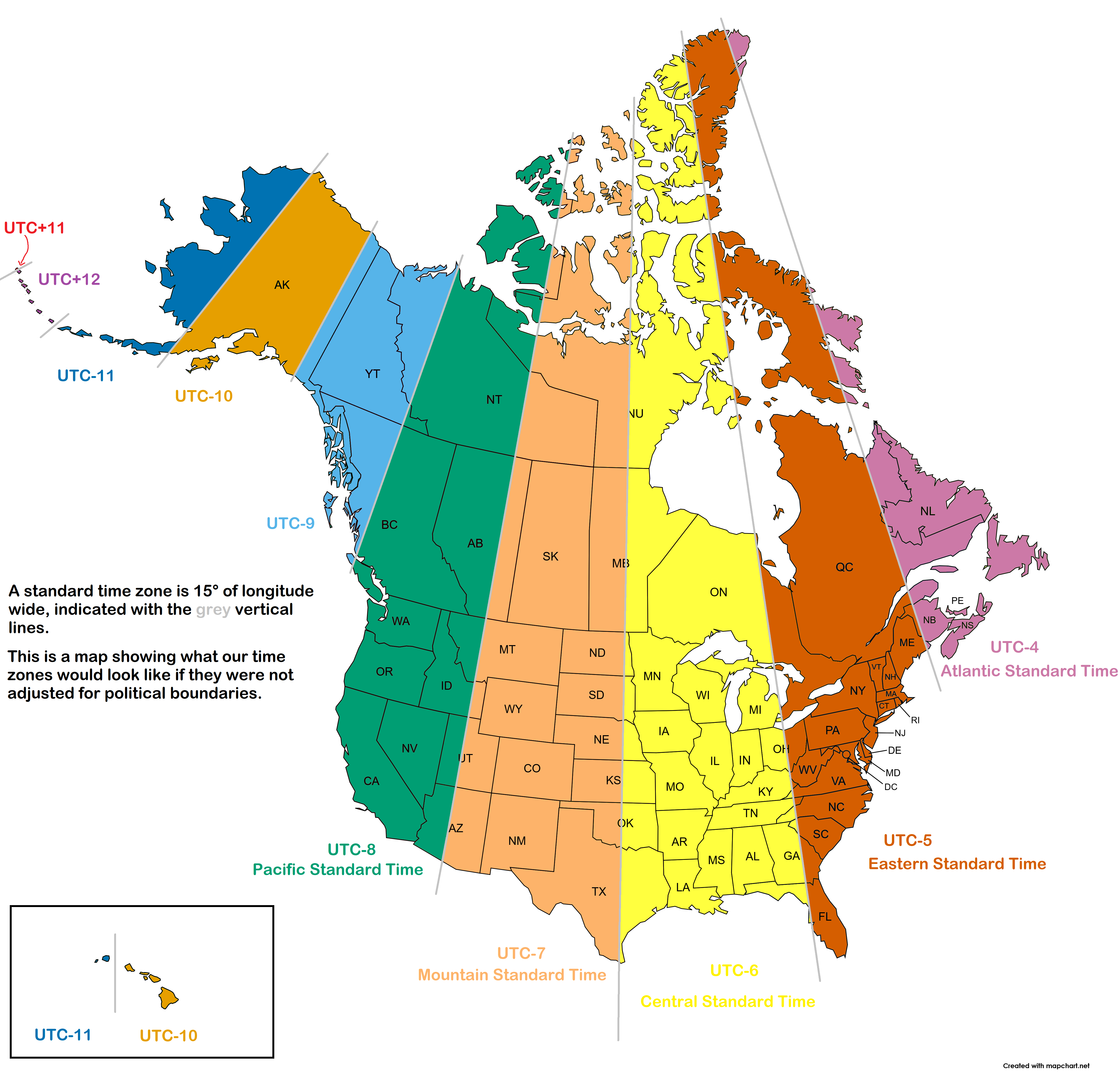
As you’ll see, there’s barely a border that actually aligns with the 15-degree divisions, and apart from Saskatchewan, Nova Scotia and PEI, no province or territory is wholly within one time zone. And in the far north that problem is exacerbated as you’re dealing with degrees of latitude - not kilometres of distance - so you get a single island that’s in three time zones. In much of the rest of the world, the decision is made nationally, regardless of the relationship of the borders to the 15-degree divisions.
The bits of the Yukon Territory and New Brunswick (and, for all its weird half-hour difference, Newfoundland and Labrador) that fall outside their “true” time zones could be handled fairly simply with little wrinkles. You could argue that the territories are so sparsely populated that their time zones could just bow to political expediency and embrace the whole area regardless of temporal accuracy. But throughout the country too many of the borders are way too far out, so the 15-degree-province idea, for all its accuracy, had to be junked. Not that anybody actually proposed it. As far as I know.
So, being Canada, they were polite about it and did something that was neither politically nor mathematically accurate, creating a series of arbitrary time zones which, while they are almost never chronologically accurate according to the sun, work simply because they are generally agreed.
Here and there.
Sort of.
Anyway, in the early days it didn’t really matter; few people made cross-country journeys and those who did, travelled so slowly that time zones were relatively unimportant. So separated were many communities that they kept their own time, so you could spend four hours travelling somewhere and disorientatingly find yourself arriving only three-and-a-half hours after setting off, and having to reset your watch. But it probably seemed quite normal, like travelling musicians having to retune their instruments to different pitch standards in different cities. As with many other countries, it was the arrival of the railway that made the issue a live one. Suddenly, you could travel many hundreds of miles in a relatively short time and timetables in far distant towns had to be aligned
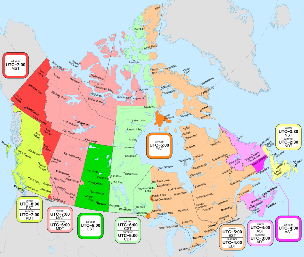
So, under this new pragmatic plan, you’re expecting that the time zones align with the provincial and territorial borders, even though they often span many degrees of latitude. And indeed they do.
Here are there.
Sort of.
Because here comes the other big one.
Canada follows Daylight Saving Time.
Here and there.
Sort of.
But in any case, consistently inconsistently.
From the first Sunday in November to the second Sunday in March the time zones are “standard time zones” (PST, MST, CST, etc.)7 For the rest of the year (the second Sunday in March to the first Sunday in November), it’s Daylight Saving Time (PDT, MDT, CDT, etc.) I won’t bother explaining the background, but it’s not, as people often believe, to please cattle wanting to be milked at the “right time” (have you ever seen a cow wearing a watch?), but rather a single golfer in Ontario wanting to get another round in.
So that’s simple isn’t it? On the appropriate days at 2 am local time (in most places…) the time hops forwards or backwards an hour across the entire country, thereby maintaining the relative differences between the various time zones.
Here and there.
Sort of.
Time is not entirely federally controlled. It’s not even provincially controlled. In fact, it’s decided by the Canadian Radio-television and Telecommunications Commission (CRTC) but they seem to be open to very local arguments, so they’ve made various changes over the years.
So the standard time zones don’t necessarily coincide with the corresponding daylight saving time zones.
Enumerating all the variations would be tiresome for both of us.8 So I think I’ll leave it there, except to note the time we were driving through south eastern British Columbia and unexpectedly crossed into the new time zone because we’d entered an area that preferred to use Mountain time. Then, a little time later we went back into Pacific time in accordance with that area’s preference, before finally crossing the border into Alberta and re-entering Mountain Time. And let’s not get into what happens when you’re in the city that’s in two provinces…
So here’s a map what happens in reality.
Here and there.
Sort of.
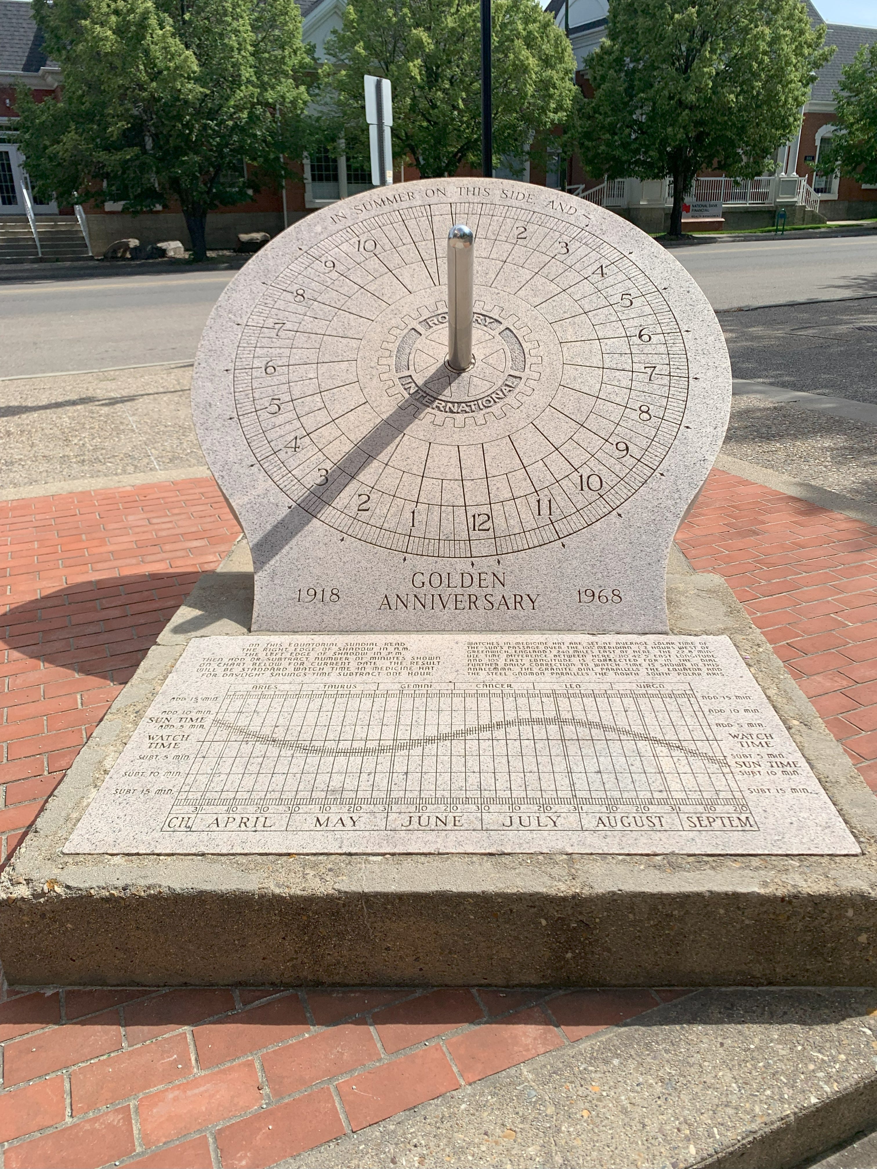
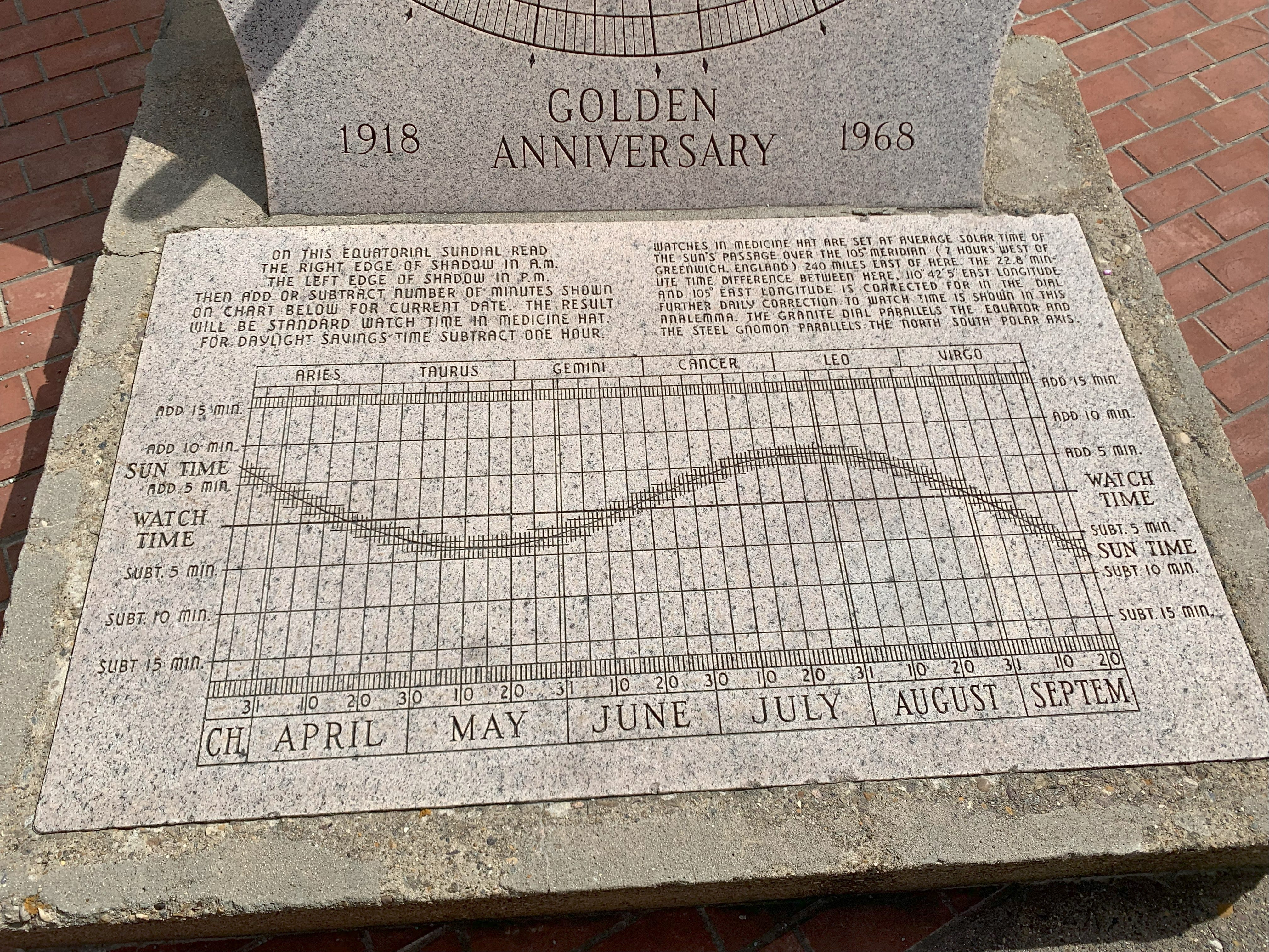
If you think that’s complicated, here’s a sundial we saw in Medicine Hat, with instructions for adding something between 0 and 10 minutes to the indicated time, depending on what month it is. And, of course, relying on it being sunny. We had to go back because the sun went behind a cloud before we’d had time to work it out.
Anyway, it’s an issue that comes up regularly for discussion and British Columbia has decided to ditch Daylight Saving Time. But being polite Canadians, they’re waiting for Washington and Oregon to decide so they can all do it together.
In addition, the competition between Ontario and Quebec to see which province can cause the greatest chaos by means of road works has caused some reroutings.
For the purposes of this post, I’m accepting the proposition that the world is not flat.
141 - 52 = 89 degrees. 1 degree = 4 mins. 89x4 = 356 mins = 5 hrs 56 mins. Even I’m confident up to this point.
The idea of having a time zone every degree [four minutes] is clearly so ludicrous that I expect some nation’s government to propose it at any moment.
That’s not an uncommon colonialist approach to territory; qv chunks of Africa and the middle east, where the straight lines ignored any sociological groupings – dividing homogenous populations and forcing together mutually antagonistic ones, lighting the touch paper for some of the major conflicts of today.
That means there are several exclaves where, to get to another part of one country, you have to go through the other one and two passport controls. Some of these are historically amusing enough that I might write about them in due course.
It used to be from the first Sunday in April to the last Sunday in October but legislation was passed in 2006 changing it. But just as they enjoy being half an hour off the rest of the country, Newfoundland and Labrador decided to delay the observance until 6 November 2011, though they did move the moment of change from 12:01am to 02:00.
Here, I’m writing as if I had only the one reader - you, dear subscriber - though it’s my fervant hope to have some multiple of that level of readership.
Fun facts, John. Keep up the good info, and safe travels.
Well, seeing as now you're both there, could you please sort it out as you travel through? Ta 🤣